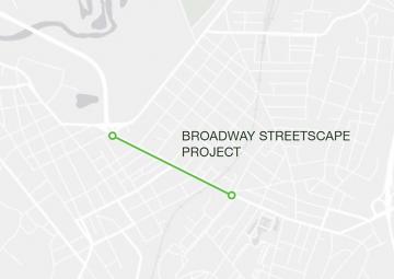
Broadway Streetscape Project
Project Goals
- Improve traffic safety for all street users and pedestrian and bicycle access on Broadway from St. James Street to Grand Street.
- Improve transit and traffic flow through signalization optimization from St. James Street to Foxhall Avenue.
- Enhance aesthetics of the business corridor with new sidewalks, lighting, street furniture, and bicycle facilities.
- Incorporate green infrastructure including bioswales and trees in the sidewalks to redirect stormwater away from the drainage system.
This project renovates Broadway from East St. James Street to Grand Street and will include:
- new ADA accessible sidewalks
- paving of the entire roadway
- new street lane configuration for parking, bikes, and vehicles that improve safety for all users
- synchronized traffic lights that will move vehicular traffic more quickly at a consistent, safe speed
- new traffic and wayfinding signs
- 49 bioswales that divert stormwater from flowing into the Rondout Creek, reduce the stormwater volume that goes to the city’s water treatment plant and improve water quality, and add greenery
- 2 interpretive panels that explain the bioswales
- 22 benches
- 76 new healthy street trees that are appropriate for the environment and will not heave the sidewalk
- 235 deciduous shrubs, 1470 herbaceous plants
- 23 trash and 23 recycling cans
- 28 bike racks
LATEST UPDATE: 6/4/21
Broadway Streetscape: continuing paver installations along the north side. PLB continues with sidewalk and curb grading including bioswale installation. Additional plantings and watering are scheduled this week.
Broadway Sewer: Work continues on connecting laterals including removing old lead water lines. Reconstruction of the south side should start block by block this week. Traffic patterns during the work hours will shift back and forth as work is being done on both sides of the road.
Development Status: Build
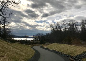
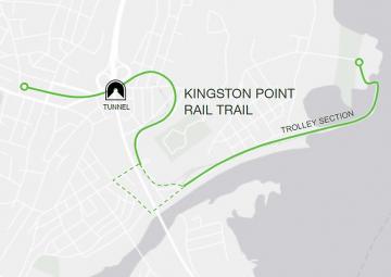
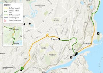
Kingston Point Rail Trail
Once complete*, the Kingston Point Rail Trail will provide a safe, accessible pedestrian and bicycle route from the Rondout waterfront to Midtown Kingston. The trail traverses multiple neighborhoods and offers stunning views of the Kingston Point Light House, Hudson River, and Rondout Creek Harbor. A restored 19th century railroad tunnel and shared trolley section along the waterfront highlight Kingston's historic railroad legacy. Visit the Trolley Museum of New York website to find out more information about Kingston's tourist trolley line.
*Phase 2 of the Kingston Point Rail Trail project (between Garraghan Dr. and the Trolley Museum) is in its design phase and is currently unconstructed. In the meantime, trail users can utilize on-road connections to access the waterfront portion of the trail, which have undergone pedestrian and cycling improvements through the Waterfront Shared Streets Project.
Development Status: Complete
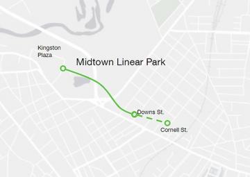
Midtown Linear Park
The Midtown Linear Park (MLP), owned by Ulster County, is a 12-foot wide 0.8-mile asphalt-paved shared-use path in the City of Kingston that follows the former Ulster & Delaware Railroad Corridor from the east side of Cornell Street to Westbrook Lane. Construction of the first phase of the path was completed in 2022, and the County envisioned that the section between Cornell and Downs Streets, which is approximately 0.55 acres could be transformed into a park. The County is currently undergoing a community design process for this section of the trail. To learn more about this opportunity and to participate visit Participate Ulster.
The MLP provides improved pedestrian and bicycle access to high quality, affordable food and other shops and services for residents in Midtown. This recreational amenity and park space promotes healthier, safer and stronger communities by improving quality of life for families and children in Midtown Kingston.
Development Status: Complete
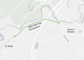
O&W Connector Trail
The O&W Connector Trail, formerly known by its project name, the Kingston Rail Trail, is complete. The 1.8-mile O&W Connector begins at a trailhead on Washington Avenue in Kingston and ends at a junction with the O&W Rail Trail along Route 209 in the Town of Hurley. This new trail connects the Kingston Greenline system with the 27-mile O&W Rail Trail.
The O&W Connector, which was recommended in the County’s 2008 Non-motorized Transportation Plan, is the most recent addition to the County’s efforts to develop an interconnected Rail Trail system throughout Ulster County. Trails built by the County in recent years include the Midtown Linear Park, the Ashokan Rail Trail, and the Hudson Valley Rail Trail.
When you visit the trail, check out the Move-A-Mile signage!
The Move-A-Mile is a half-mile out-and-back paved path, marked with new signage inviting people to walk, roll, stroll, or run. County health officials described the route as designed for people of all ages and abilities. It sits on the O&W Connector Trail, at 495 Washington Avenue in Kingston, which links the Kingston Greenline system to the 27-mile O&W Rail Trail.
The project is part of the Department of Health’s “Movement is Medicine” initiative, a countywide effort to promote physical activity as a tool for preventing chronic disease and improving overall well-being.
Development Status: Complete
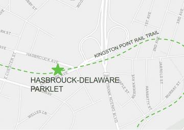
Hasbrouck Delaware Parklet
The Hasbrouck-Delaware Parklet is a small, community-oriented greenspace along the Kingston Greenline in Midtown.
The hardscape phase of the Hasbrouck-Delaware Parklet wrapped up in December 2018 and included construction of sidewalks, crosswalks on speed tables, extension of the park area and re-orientation of the roadway intersection, clearing of brush, addition of topsoil, and planting of grass to stabilize the slopes and avoid erosion. The Kingston Land Trust is also working with the City of Kingston to fund a staircase to connect the site to the Kingston Point Rail Trail, near the entrance to the trail's tunnel under the intersection.
The landscape design of the Parklet was done by KaN Landscape Design Inc., and funded with a grant from Hudson River Valley Greenway - Greenway Conservancy Program Grant to the Kingston Land Trust. KaN also donated many additional hours of professional services to the design of the project, along with other members of the Community Design Workgroup of the Kingston Greenline Committee. The Kingston Land Trust is currently fundraising for the landscape implementation phase of the project, including installation of plantings and preparations for future amenities.
Development Status: Build
Empire State Trail
From the Empire State Trail website:
In 2017, Governor Andrew Cuomo launched the Empire State Trail to promote outdoor recreation, encourage healthy lifestyles, support community vitality, and bolster tourism-related economic development.
The 750-mile Empire State Trail showcases New York’s special places, diverse history, and iconic landscapes.
The Trail welcomes bicyclists and walkers of all ages and abilities to experience the Empire State’s urban centers, village main streets, rural communities, and diverse history, from New York City through the Hudson River Valley, west to Buffalo along the Erie Canal, and north to the Champlain Valley and Adirondacks.
The Empire State Trail connects New York’s extraordinary experiences, people, and places.
This 6.5-mile Empire State Trail section through the City of Kingston has varied conditions. Two off-road paths welcome walkers and bicyclists of all abilities. Conversely, two connecting on-road sections are intended for experienced bicyclists comfortable traveling next to vehicle traffic. This section starts slightly south of Kingston, at a parking lot at the intersection of Route 32 and Rockwell Lane. Heading north, the first 2.5 miles are on-road, designated on Route 32 and city streets. The off-road Kingston Point Rail Trail starts at the intersection of West Chestnut St and Jansen Ave, looping east 1.5 miles to Roundout Landing. From there, a 1-mile on-road route is designated on the shoulders of East Strand St. The second 1.5-mile off-road path, named the Hudson River Brickyard Trail, runs from North Street to John Street in East Kingston. Click here for interactive map.
Development Status: Complete
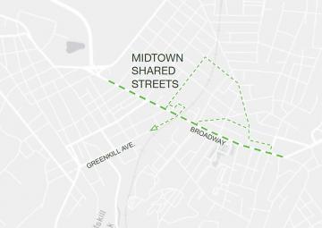
Midtown Shared Streets
The Midtown Shared Streets project includes the installation of trafic calming features to improve pedestrian and bicycle saftety and access including crosswalks, bicycle sharrows (shared arrows), and signs that alert motorists to pedestrian crossing, bicycles in the road, and the Kingston Greenline route. The project focuses on Cornell, Ten Broeck, Foxhall, and Jansen Ave.
Development Status:
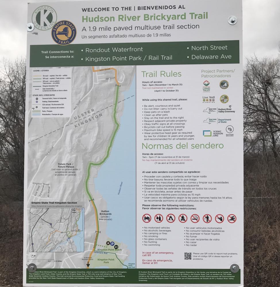
Hudson River Brickyard Trail
This section, called the Hudson River Brickyard Trail, passes through 520 acres of formerly industrial land, now known as Hudson Cliffs, which Scenic Hudson protected last year. With New York State DOS funding, the City of Kingston, the Town of Ulster, Scenic Hudson, and regional and local partners collaborated to identify a new trail alignment, obtain local planning approvals and advance the project into construction. The trail’s route was chosen to minimize impacts to natural resources, maximize views of the Hudson River, and access future recreational amenities.
All parking for the Hudson River Brickyard Trail is located at Kingston Point Beach. From the beach, pedestrians take a short wood-chipped path, which leads to North Street and through the Hutton Brickyard property onto the new Hudson River Brickyard Trail. Trail maps are posted at Kingston Point Beach and the pedestrian gate at Hutton Brickyards. Winter hours are posted from 7:00am-5:00pm. The pedestrian gates at the property are closed after 5:00pm through March 31, 2021. The trail is not maintained in the winter months but is open for recreation.
The remainder of the Hudson Cliffs property currently is closed to the public while Scenic Hudson continues to evaluate its natural and industrial features with a team of consultants led by the landscape architecture firm OLIN. In early 2021, the organization plans to host opportunities for community residents and stakeholders to help shape a vision for the future park. To learn more about the property, visit https://hudsoncliffsparkinfo.org/
The Empire State Trail is the largest multi-use trail in the nation. This network of trails will contain 750-miles of pathways for walking/hiking and bicycling along scenic vistas and through New York’s historic communities.
Updated 2/16/2021
Development Status: Complete